Territory
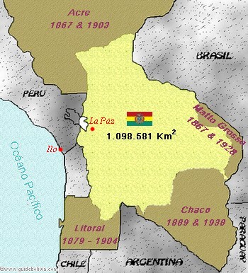 Bolivia has an area of 1,098,581 Km2 (approximately five times the area of Great Britain). Since gaining
independence in 1825, Bolivia has lost about half of the area of its territory during successive conflicts
against all the neighboring countries: loss of
Litoral during the Pacific war (Chile), annexations of the area of
Acre in the North and Matto Grosso in the West (Brazil),
loss of Chaco Central (Argentina) and
Chaco Boreal in the South-East (Paraguay).
Bolivia has an area of 1,098,581 Km2 (approximately five times the area of Great Britain). Since gaining
independence in 1825, Bolivia has lost about half of the area of its territory during successive conflicts
against all the neighboring countries: loss of
Litoral during the Pacific war (Chile), annexations of the area of
Acre in the North and Matto Grosso in the West (Brazil),
loss of Chaco Central (Argentina) and
Chaco Boreal in the South-East (Paraguay).
Country totally enclosed in the middle of the South American continent without any access to the oceans. In 1992, presidents Fujimori (Peru) and Paz Zamora (Bolivia) signed agreements defining a Bolivian 'free zone' of 327 hectares in the Peruvian harbour of Ilo, à 500km de La Paz, about 500km from La Paz. This provides Bolivia with an economically important access to the Pacific coast.
Topography
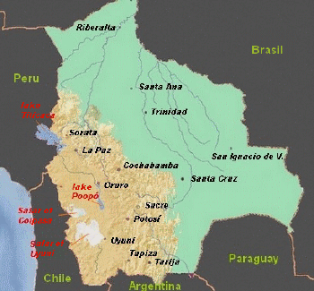 Bolivia is divided into three main
geographical areas, each one is covered by three departments.
Bolivia is divided into three main
geographical areas, each one is covered by three departments.
- Andean zone (alt. 2500m-6500m): This geographical region includes the departments of La Paz, Oruro and Potosí. It represents 28% of the national territory and comprises the mountainous regions of Cordillères Occidental, Real y Oriental and also the Andean plateau (altiplano: large and arid region 3500-4000m above sea level).
- Sub-Andean zone (alt. 2000m-2500m): This geographical region includes the departments of Cochabamba, Chuquisaca and Tarija. It represents 13% of the national territory and consists of a succession of mountain ranges of medium altitude surrounding large valleys with temperate climate, like the Yungas near La Paz.
- Lowlands (llanos) (<2000m): This geographical region includes the departments of Santa Cruz, Beni and Pando. It represents 59% of the national territory. These are warm regions of the Amazonian plains and also the dry region of Chaco.
Bolivia is commonly regarded as a mountainous country. Actually, more than half (59%) of the area of Bolivia is classified as lowland.
Major Bolivian Cities - Summary Information
| Cities | Inhabitants (2003) | Altitude (m) | Department |
| Santa Cruz de la Sierra | 1,170,000 | 440 | Santa Cruz |
| La Paz | 830,000 | 3,640 | La Paz |
| Cochabamba | 815,000 | 2,560 | Cochabamba |
| El Alto | 730,000 | 4,050 | La Paz |
| Oruro | 210,000 | 3,710 | Oruro |
| Sucre | 205,000 | 2,790 | Chuquisaca |
| Tarija | 140,000 | 1,870 | Tarija |
| Potosí | 140,000 | 4,070 | Potosí |
| Montero | 80,000 | 300 | Santa Cruz |
| Trinidad | 70,000 | 240 | Beni |
| Yacuíba | 80,000 | 880 | Tarija |
| Riberalta | 65,000 | 130 | Beni |
| Tupiza | 20,000 | 3,170 | Potosí |
| Cobija | 20,000 | 220 | Pando |
| San Ignacio de Velasco | 20,000 | 590 | Santa Cruz |
| Ascensión | 13,000 | 240 | Santa Cruz |
| Caranavi | 13,000 | 1,020 | La Paz |
| Uyuni | 11,000 | 4,060 | Potosí |
| Rurrenabaque | 10,000 | 300 | Beni |
| Concepción | 6,000 | 500 | Santa Cruz |
| Copacabana | 4,200 | 3,820 | La Paz |
| Coroico | 3,500 | 1,800 | La Paz |
| Sorata | 2,200 | 2,700 | La Paz |
Famous Bolivian Summits
| Summit | Altitude (m) |
| Sajama | 6,542 |
| Illampu | 6,485 |
| Illimani | 6,462 |
| Parinacota | 6,348 |
| Huayna Potosí | 6,088 |
| Acotango | 6,052 |
| Lincancábur | 5,930 |
| Mururata | 5,868 |
Bolivian World Heritage Sites Registered by UNESCO
- Mining city of Potosí (1987)
- Jesuit missions of Chiquitos (1990)
- Historic city of Sucre (1991)
- Fortress of Samaipata (1998)
- Noel Kempff Mercado national park (2000)
- Spiritual and political Centre of Tiwanaku (2000)
- Qhapaq Ñan Andean road network (2014)