Geography
 The Andean cordillera is the largest mountain range
in the world, extending approximately 8000km from Venezuela to the extreme South of Chile. At 6959m
above sea level, Aconcagua (bordering Argentina and Chile) is the highest peak in the Andes.
The Andean cordillera is the largest mountain range
in the world, extending approximately 8000km from Venezuela to the extreme South of Chile. At 6959m
above sea level, Aconcagua (bordering Argentina and Chile) is the highest peak in the Andes.
The Andes were born 170 million years ago as a result of the collision between two tectonic plates (the Nazca plate plunging under the South American plate). Many active volcanoes and frequent earthquakes are visible manifestations of the intense geological activity in this area. One hundred million years ago, the Andes suffered from significant erosion, creating immense sedimentary basins, of which the Bolivian altiplano is the principal representative.
The Andes are divided into three major formations:
- The northern Andes (Colombia, Ecuador, Venezuela),
- The central Andes (Peru, Bolivia),
- The southern Andes (Argentina, Chile).
Bolivia occupies the central part of the Andes. In this area, one can distinguish three principal branches:
- The Cordillera Occidental (to the West)
- The Cordillera Central (in the central region)
- The Cordillera Real/Oriental (to the East)
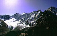
The Cordillera Real
The Cordillera Real is about 1200km long and contains more than 600 saddles with altitudes greater than 5000metres. The mountain range marks a separation between the lowlands of the Amazonian basin and the Andean high plateau (altiplano).
Noteworthy among the principal peaks are
-
Illimani
 volcano (6462m) dominating the city of La Paz,
 -
Illampu
(6485m) highest peak of the Cordillera Real,
-
Huayna Potosi
(~6088m) dominating the Zongo valley and
Milluni ,
- The Condoriri group which includes 13 peaks, the highest being 5648m above sea level.
In front of the Huayna Potosi, the glacier of Chacaltaya (5400m) awaits hikers with what used to be the highest ski resort in the world (until the recent closure of the ski lift). The bus or taxi brings you up a rocky track and deposits you close to the glacier, but it is necessary to walk the last few hundred metres. You are afforded beautiful views of the altiplano (when the weather permits, i.e. during the dry season), and a small restaurant at 5270m. An impressive altitude to reach without undue effort!
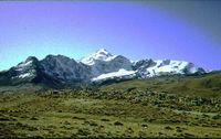 Close to Chacaltaya, one can visit the valley of Milluni, including the abandoned
mining village, the scarlet-coloured lagoon, and the Indian cemetery. Great photo-opportunities for pictures of Milluni with Huayna
Potosi in background. This area of the altiplano is particularly densely populated with lamas.
Close to Chacaltaya, one can visit the valley of Milluni, including the abandoned
mining village, the scarlet-coloured lagoon, and the Indian cemetery. Great photo-opportunities for pictures of Milluni with Huayna
Potosi in background. This area of the altiplano is particularly densely populated with lamas.
The Cordillera Occidental
This is a volcanic range running North-South and forming the natural border of Bolivia with Peru and Chile.
Among the principal volcanoes, the following are noteworthy:
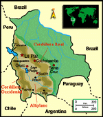
Photo Gallery


