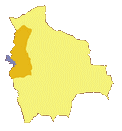
The highest capital of the world
With an average altitude of 3650 meters above sea level,
La Paz ![]() is the highest capital of the world. The altitude
is the first thing that one notices when landing at the international airport of
El Alto
is the highest capital of the world. The altitude
is the first thing that one notices when landing at the international airport of
El Alto ![]() (4000m), breathing becomes difficult
when one has to carry a 20kg suitcase...
(4000m), breathing becomes difficult
when one has to carry a 20kg suitcase...
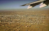 En route to La Paz from the airport, you can already get a
glimpse of the city of El Alto: a large metropolitan area (700,000 inhabitants) built on the outskirts of La Paz, swept by icy winds
of the altiplano, poor neighborhoods (75% of the population lives below the poverty line). El Alto offers a refuge for the poorest citizens,
and its neighborhoods slowly expands over the limitless space of the Andean plateau, fed by an unceasing flow of "campesinos" (farmers)
attracted by the economic wealth of the capital.
En route to La Paz from the airport, you can already get a
glimpse of the city of El Alto: a large metropolitan area (700,000 inhabitants) built on the outskirts of La Paz, swept by icy winds
of the altiplano, poor neighborhoods (75% of the population lives below the poverty line). El Alto offers a refuge for the poorest citizens,
and its neighborhoods slowly expands over the limitless space of the Andean plateau, fed by an unceasing flow of "campesinos" (farmers)
attracted by the economic wealth of the capital.
Que linda La Paz!
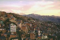 La Paz (with some 800,000 inhabitants) is constructed in a steep-sided
canyon
La Paz (with some 800,000 inhabitants) is constructed in a steep-sided
canyon ![]() on the flanks of the altiplano about 60km to the east of Titicaca Lake.
At the entrance of El Alto, the 20km highway quickly plunges down to the capital, in the middle of dusty buildings made of red and beige bricks.
Let the taxi (or the minibus for those with tighter budgets) guide you, and enjoy a few minutes contemplating the spectacular
panoramic view over La Paz with Illimani peak in background (though the peak may not always be visible
during the rainy season!).
on the flanks of the altiplano about 60km to the east of Titicaca Lake.
At the entrance of El Alto, the 20km highway quickly plunges down to the capital, in the middle of dusty buildings made of red and beige bricks.
Let the taxi (or the minibus for those with tighter budgets) guide you, and enjoy a few minutes contemplating the spectacular
panoramic view over La Paz with Illimani peak in background (though the peak may not always be visible
during the rainy season!).
Mountain and people
 La Paz sprawls between 3000 and 4000 metres
above sea level. The rich residential neighbourhoods, characterised by paved and well structured streets, luxurious villas and gardens
occupy the lower part of the city in contrast to the poorest areas distributed on the highest part of the capital with their
atrocious roads, anarchic and poorly finished buildings. In the centre of the city (average altitude 3600m), the numerous modern
structures built all along the principal avenue (Prado) and the daily traffic jams reflect the economic activity of the growing
city whose geographic expansion has been blocked by the mountain flanks.
La Paz sprawls between 3000 and 4000 metres
above sea level. The rich residential neighbourhoods, characterised by paved and well structured streets, luxurious villas and gardens
occupy the lower part of the city in contrast to the poorest areas distributed on the highest part of the capital with their
atrocious roads, anarchic and poorly finished buildings. In the centre of the city (average altitude 3600m), the numerous modern
structures built all along the principal avenue (Prado) and the daily traffic jams reflect the economic activity of the growing
city whose geographic expansion has been blocked by the mountain flanks.
 The river Choqueyapu flows through the middle of the canyon.
Formerly exploited by the Spaniards for its gold ore measures, the Choqueyapu river is today little more than a vast sewer,
receiving the waste water of La Paz. Fortunately, the river runs mostly underground, which has the advantage of filtering out the
offensive odours in the centre of the city. Alongside the river, one can observe many cholitas (Aymaras Indian women) washing
their polleras (traditional skirts).
The river Choqueyapu flows through the middle of the canyon.
Formerly exploited by the Spaniards for its gold ore measures, the Choqueyapu river is today little more than a vast sewer,
receiving the waste water of La Paz. Fortunately, the river runs mostly underground, which has the advantage of filtering out the
offensive odours in the centre of the city. Alongside the river, one can observe many cholitas (Aymaras Indian women) washing
their polleras (traditional skirts).
Historical milestones
Originally built on the remains of the former civilization of Tiahuanaco, "Nuestra Señora de La Paz" was founded on October 20, 1548 by don Alonzo de Mendoza to commemorate the end of the Spanish civil war against Diego Almagro and Francisco Pizarro. Very shortly after, the initial camp in the vicinity of Laja, was moved to a more friendly region (with milder climate and veins of gold) in the valley of Chuquiago Marka (named after the former inhabitants of the region).
In 1555, the emperor Charles V gave to The Paz its blazon, marking the beginning of political control of the city by the Spaniards.
At the end of the XVIIIth century and beginning of the XIXth century, La Paz was besieged by armed groups of Aymaras from the altiplano on a number of occasions. Successive revolts were curbed by the Spaniards, but many buildings and churches of the city were damaged as a result.
1809, independence movement: La Paz rebels against the Spanish domination in a patriotic movement headed by Pedro Domingo Murillo. On July 16 1809, Murillo was executed (hanged) with other compatriots in the middle of the square that today bears his name.
La Paz has been home to the Bolivian government since October 25, 1899.
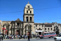
- San Francisco church (1548, rebuilt in the XVIIIth century) combines Spanish baroque and Indian styles
- Plaza Murillo (originally plaza of the españoles)
The cathedral (XIXth century)
Presidential Palace and - Museums galore:
San Francisco museum
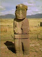
Archeological Museum of Tiahuanaco
Museum of ethnography and folklore
Museo de metales preciosos pre-colombinos
Museo del litoral (documenting the Pacific war with Chile)
Museum of customs Juan of Vargas (evolution of the capital with time)
Museo Casa Murillo
Museo Tambo Quirquincho (art and traditional Carnival masks) - Jaen street (charming street of colonial style)
- Hotel restaurant Torino (patio decorated in colonial style)
Lively La Paz
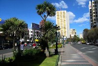
- Avenues Mariscal Santa Cruz and Prado are the principal arteries of the centre of La Paz
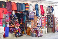
- Markets:
Sagárnaga and Linares streets
(craft industry and witchcraft),
San Fransisco square,
Camacho and Lanza markets (food),
Black market,
Eloy Salmon (electronics)
Perez Velasco,
Uyustus (clothing)
Market of the alasitas (around January 28)
Charming La Paz
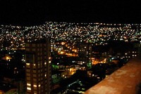
- Panoramic restaurants of the (5 star) hotels Plaza Radison, and Presidente. At night, the flanks of the surrounding mountain sparkles with millions of spot lights.
- Folklore: Carnival, Gran Poder festival (May June) & start of the university year
Excursions around La Paz
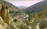
- Valley of the Moon
: canyon located 10km south of the centre of La Paz, with a lunar landscape
where erosion has sculpted the rock like a multitude of chimneys.
- Zoo in Mallasa
- Muela del Diablo: (devil's molartooth): located to the south of La Paz - a day is necessary to complete the excursion to the summit. The tour provides a splendid overview of the capital and the valley of the Moon.
- Tiahuanaco (or Tiwanaku)
(30km to the West): ruins of the ancient pre-Inca civilization
- Lake Titicaca (60km to the west of La Paz)
- Chacaltaya: 35km from La Paz, formerly the highest commercial skiing area in the world at 5230m, the infrastructure of the station no longer operates (except the bar-restaurant chalet), but there is a breathtaking view (in clear weather!) over La Paz, El Alto and the altiplano.
- Tropical Valleys of the Yungas (Coroico, Chulumani) and Zongo.
- Sorata
- Trekking in the Cordillera Real
- Urmiri thermal resort (hotel Gloria)
Population: 1,560,000
Altitude: 3650m
Foundation: 1548
Anniversary: October 20
Photo Gallery


