Geography
 The
altiplano
The
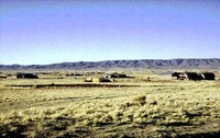
altiplano ![]() is a "high plain" about 4000 metres
above sea level, forming a strip 900km long and 100km wide, and spreading over a territory mainly covering western
Bolivia and small parts of Peru, Chile and Argentina.
is a "high plain" about 4000 metres
above sea level, forming a strip 900km long and 100km wide, and spreading over a territory mainly covering western
Bolivia and small parts of Peru, Chile and Argentina.
The altiplano is a basin bounded by two mountain ranges running North-South: The Cordillera Occidental in the West, and the Cordillera Real in the East. Two major lakes exist on the altiplano: the Titicaca lake (to the North), and Poopo lake (in the centre) supplied by water from Titicaca via the Desaguadero river.
Climate
The climate on the altiplano is cold and dry, humidity from tropical regions being blocked by the Cordillera Real. The southern regions are more affected by drought than northern ones; they are swept by dry winds and do not benefit from any thermal regulation, such as that provided by Lake Titicaca in the North.
Minerals, including copper, silver, tin, tungsten, lithium and gold, abound in the wild and inhospitable southern altiplano desert region).
Vegetation
The arid climate determines the vegetation of the altiplano. The puna (quechua word meaning "depopulated"), is covered by rocky soil studded with bushes and wisps of yellowish herb spreading as far as the eye can see. .
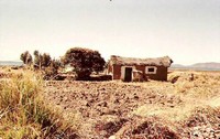 Oases of life appear around villages and isolated
peasant houses. In these nurtured locations, quinoa or various types of potatoes are cultivated. Trees are
rare. In the middle of this huge desert area, a eucalyptus shading the yard of a little farm built of mud
and stones is a sure sign of a human presence.
Oases of life appear around villages and isolated
peasant houses. In these nurtured locations, quinoa or various types of potatoes are cultivated. Trees are
rare. In the middle of this huge desert area, a eucalyptus shading the yard of a little farm built of mud
and stones is a sure sign of a human presence.
Animals
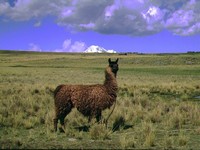 In general, cattle and llamas live close to the farms. The donkey is
also a very popular animal on the altiplano; they can often be seen resting after long pack-saddle day. Pigs
and poultry live in the villages, watched over by placid dogs sleeping in the dust.
In general, cattle and llamas live close to the farms. The donkey is
also a very popular animal on the altiplano; they can often be seen resting after long pack-saddle day. Pigs
and poultry live in the villages, watched over by placid dogs sleeping in the dust.
The altiplano is also populated with wild animals including viscachas, partridges, and vicunas.
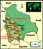
Photo Gallery
